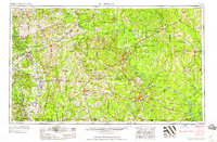
1958 Map of El Dorado
USGS Topo · Published 1958About this map
The Ouachita River and its industrial corridor dominate this landscape of the late fifties, where the U S Naval Ammunition Depot and scattered Oil and Gas Fields define the local economy between Camden and El Dorado. The river's navigability is managed through structures like Lock and Dam No 6 and Lock and Dam No 8, supporting a region heavily reliant on both water and rail transport. Significant rail infrastructure, including the St Louis Southwestern Ry and the Missouri Pacific RR, connects established timber and agricultural hubs like Hope, Warren, and Fordyce.
Find a feature on this map
120 named features on this map. Tap any name to fly to it.
Don’t see what you’re looking for? This feature index may not catch every label — zoom into the map to look around manually.
Map Details
Editions of this 1958 El Dorado Map
3 editions found

Other maps of this area

1901 · Gurdon
USGS Topo · 1:125,000

1903 · Camden
USGS Topo · 1:125,000

1906 · Caddo Gap
USGS Topo · 1:125,000

1907 · Atlanta
USGS Topo · 1:62,500

1909 · Texarkana
USGS Topo · 1:62,500

1910 · Atlanta
USGS Topo · 1:62,500

1913 · De Queen
USGS Topo · 1:125,000

1922 · Sarepta
USGS Topo · 1:62,500

1924 · Sarepta
USGS Topo · 1:62,500

1927 · El Dorado
USGS Topo · 1:62,500