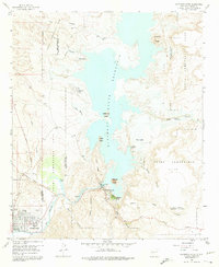
1958 Map of Elephant Butte
USGS Topo · Published 1975About this map
Truth or Consequences anchors the southwestern corner of this mid-century survey, shown alongside its Natl Guard Armory and St Anne Hospital. The landscape is dominated by the Elephant Butte Reservoir, an impoundment of the Rio Grande that submerged much of the surrounding terrain while creating new points of interest like Hot Springs Landing and Lions Beach. The prominent Elephant Butte Dam stands as a focal point of infrastructure, supported by a nearby Powerhouse and Fish Hatchery.
Find a feature on this map
42 named features on this map. Tap any name to fly to it.
Don’t see what you’re looking for? This feature index may not catch every label — zoom into the map to look around manually.
Map Details
Editions of this 1958 Elephant Butte Map
4 editions found
Other maps of this area

1954 · Tularosa
USGS Topo · 1:250,000

1958 · Tularosa
USGS Topo · 1:250,000

1958 · Elephant Butte
USGS Topo · 1:24,000

1959 · Engle
USGS Topo · 1:62,500

1961 · Huerfano Hill
USGS Topo · 1:24,000

1961 · Black Bluffs
USGS Topo · 1:24,000

1961 · Crocker
USGS Topo · 1:24,000

1961 · Williamsburg
USGS Topo · 1:24,000

1961 · Cuchillo
USGS Topo · 1:24,000

1979 · Truth or Consequences
USGS Topo · 1:100,000
Featured Places
- Truth or Consequences, NM
- Elephant Butte, NM
- Rock Canyon, NM
- Hot Springs Landing, NM
- Elephant Butte Estates, NM