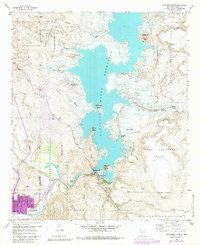
1958 Map of Elephant Butte
USGS Topo · Published 1985About this map
The Rio Grande serves as the central artery for this high-desert landscape, dominated by the massive Elephant Butte Reservoir and the engineering feat of the Elephant Butte Dam. The map documents a pivotal era for the community of Truth or Consequences, shown here following its famous name change, with local landmarks like St Anne Hospital and the Natl Guard Armory clearly identified within the city boundary.
Find a feature on this map
46 named features on this map. Tap any name to fly to it.
Don’t see what you’re looking for? This feature index may not catch every label — zoom into the map to look around manually.
Map Details
Editions of this 1958 Elephant Butte Map
4 editions found
Other maps of this area

1954 · Tularosa
USGS Topo · 1:250,000

1958 · Tularosa
USGS Topo · 1:250,000

1958 · Elephant Butte
USGS Topo · 1:24,000

1959 · Engle
USGS Topo · 1:62,500

1961 · Huerfano Hill
USGS Topo · 1:24,000

1961 · Black Bluffs
USGS Topo · 1:24,000

1961 · Crocker
USGS Topo · 1:24,000

1961 · Williamsburg
USGS Topo · 1:24,000

1961 · Cuchillo
USGS Topo · 1:24,000

1979 · Truth or Consequences
USGS Topo · 1:100,000
Featured Places
- Truth or Consequences, NM
- Elephant Butte, NM
- Rock Canyon, NM
- Hot Springs Landing, NM
- Elephant Butte Estates, NM