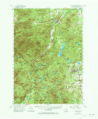
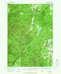
1955 Map of Elizabethtown
USGS Topo · Published 1973About this map
Elizabethtown and the surrounding high peaks of the Adirondacks are captured here during a period of transition in the mid-1950s. The settlement pattern reflects the area's deep ties to both the wilderness and industry, with the Bouquet River carving a valley through massifs like Hurricane Mtn and Giant Mtn. To the east, the industrial character of the landscape is evident in the cluster of mining-related settlements, including Mineville and Witherbee, where the terrain is marked by the presence of a Lookout Tower on Belfry Mtn.
Find a feature on this map
162 named features on this map. Tap any name to fly to it.
Don’t see what you’re looking for? This feature index may not catch every label — zoom into the map to look around manually.
Map Details
Editions of this 1955 Elizabethtown Map
5 editions found
Other maps of this area

1894 · Elizabethtown
USGS Topo · 1:62,500

1894 · Port Henry
USGS Topo · 1:62,500

1894 · Ticonderoga
USGS Topo · 1:62,500

1895 · Willsboro
USGS Topo · 1:62,500

1895 · Elizabethtown
USGS Topo · 1:62,500

1895 · Mt. Marcy
USGS Topo · 1:62,500

1895 · Ausable
USGS Topo · 1:62,500

1895 · Paradox Lake
USGS Topo · 1:62,500

1896 · Lake Placid
USGS Topo · 1:62,500

1896 · Ticonderoga
USGS Topo · 1:62,500