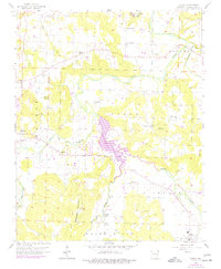
1958 Map of Elkins
USGS Topo · Published 1977About this map
The White River and its multiple forks converge in this region of Washington County, where the topography is defined by prominent elevations like Round Mountain and Robinson Mountain. Centered on the sprawling fingers of Lake Sequoyah, the landscape shows a rural network of small communities and family-named landmarks. The 1950s survey detail, updated with mid-1970s revisions, reveals the settlement patterns of Habberton, Wyman, and Elkins. Numerous small cemeteries and country churches are scattered throughout the valleys, such as Mt Vernon Ch, Sons Chapel, and Strain Ch. These sites, often situated near the many creeks like Richland Creek and Mud Creek, provide a detailed record of local genealogy and the historical agricultural economy that relied on the fertile bottomlands between the ridges.
Find a feature on this map
42 named features on this map. Tap any name to fly to it.
Don’t see what you’re looking for? This feature index may not catch every label — zoom into the map to look around manually.
Map Details
Editions of this 1958 Elkins Map
3 editions found

Other maps of this area

1898 · Winslow
USGS Topo · 1:125,000

1899 · Fayetteville
USGS Topo · 1:125,000

1900 · Eureka Springs
USGS Topo · 1:125,000

1901 · Winslow
USGS Topo · 1:125,000

1901 · Eureka Springs
USGS Topo · 1:125,000

1901 · Fayetteville
USGS Topo · 1:125,000

1904 · Fayetteville
USGS Topo · 1:125,000

1943 · St. Paul
USGS Topo · 1:62,500

1945 · Harrison
USGS Topo · 1:250,000

1946 · St. Paul
USGS Topo · 1:62,500