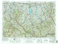
1962 Map of Elmira
USGS Topo · Published 1978About this map
Seneca Lake and Cayuga Lake anchor the central portion of this survey, illustrating the deep glacial troughs and narrow ridges that define the Finger Lakes region. The landscape is a complex intersection of mid-century industrial infrastructure and recreation, featuring the Seneca Army Depot on the shores of Seneca Lake and the established path of the Erie Canal to the north. Transportation corridors are well-developed, with the New York State Thruway cutting across the northern reaches while the Erie Lackawanna RR and Lehigh Valley RR trace the valley floors.
Find a feature on this map
140 named features on this map. Tap any name to fly to it.
Don’t see what you’re looking for? This feature index may not catch every label — zoom into the map to look around manually.
Map Details
Editions of this 1962 Elmira Map
4 editions found

Other maps of this area

1893 · Ithaca
USGS Topo · 1:62,500

1895 · Chittenango
USGS Topo · 1:62,500

1895 · Rochester
USGS Topo · 1:62,500

1895 · Ithaca
USGS Topo · 1:62,500

1895 · Elmira
USGS Topo · 1:62,500

1895 · Syracuse
USGS Topo · 1:62,500

1897 · Albion
USGS Topo · 1:62,500

1897 · Cazenovia
USGS Topo · 1:62,500

1898 · Rochester
USGS Topo · 1:62,500

1898 · Syracuse
USGS Topo · 1:62,500