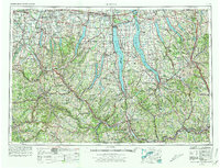
1962 Map of Elmira
USGS Topo · Published 1978About this map
Seneca Lake and Cayuga Lake dominate this mid-century portrait of the Finger Lakes region, a landscape defined by deep glacial troughs and the industrial corridors of the Allegheny Plateau. The map documents a mature network of rail lines, including the Erie Lackawanna Railroad and New York Central Railroad, which supported the manufacturing hubs of Elmira, Corning, and Ithaca. Educational institutions like Cornell University and Elmira College appear alongside significant military and conservation sites, such as the Seneca Army Depot and Montezuma National Wildlife Refuge. The terrain transitions from the broad river valleys of the Susquehanna River and Chemung River in the south to the fertile plains near Syracuse and Geneva to the north, capturing the area before the full expansion of the modern interstate system replaced older thoroughfares like U.S. Highway 20.
Find a feature on this map
225 named features on this map. Tap any name to fly to it.
Don’t see what you’re looking for? This feature index may not catch every label — zoom into the map to look around manually.
Map Details
Editions of this 1962 Elmira Map
4 editions found

Other maps of this area

1893 · Ithaca
USGS Topo · 1:62,500

1895 · Chittenango
USGS Topo · 1:62,500

1895 · Rochester
USGS Topo · 1:62,500

1895 · Ithaca
USGS Topo · 1:62,500

1895 · Elmira
USGS Topo · 1:62,500

1895 · Syracuse
USGS Topo · 1:62,500

1897 · Albion
USGS Topo · 1:62,500

1897 · Cazenovia
USGS Topo · 1:62,500

1898 · Rochester
USGS Topo · 1:62,500

1898 · Syracuse
USGS Topo · 1:62,500