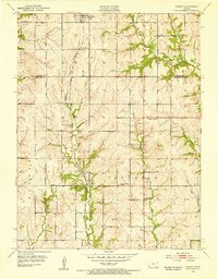
1952 Map of Elmont
USGS Topo · Published 1953About this map
Chicago Rock Island And Pacific tracks run north-south through this Kansas landscape, connecting the small grain and trade hubs of Hoyt and Elmont during the early 1950s. The map reveals a deeply rooted rural infrastructure of one-room schoolhouses and country churches, such as Capitol View Sch, Rock Sch, and the Pleasant Hill Ch. A significant historical landmark is the Old Potawatomi Reservation Boundary, which cuts across the western portion of the quadrangle, reflecting older land divisions from the previous century. Along the valley of Halfday Creek, several cemeteries including Halfday Cem and Stewart Cem provide critical touchstones for genealogists. The terrain is characterized by the branching drainage systems of Muddy Creek and Little Muddy Creek, where small-scale Quarry sites dot the hillsides near the rail line.
Find a feature on this map
25 named features on this map. Tap any name to fly to it.
Don’t see what you’re looking for? This feature index may not catch every label — zoom into the map to look around manually.
Map Details
Editions of this 1952 Elmont Map
5 editions found
Other maps of this area

1889 · Topeka
USGS Topo · 1:125,000

1894 · Topeka
USGS Topo · 1:125,000

1950 · Kansas City
USGS Topo · 1:250,000

1950 · Topeka
USGS Topo · 1:24,000

1950 · Grantville
USGS Topo · 1:24,000

1951 · Grantville
USGS Topo · 1:24,000

1951 · Topeka
USGS Topo · 1:24,000

1952 · Silver Lake
USGS Topo · 1:24,000

1952 · Elmont
USGS Topo · 1:24,000

1952 · Grove
USGS Topo · 1:24,000