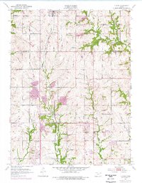
1952 Map of Elmont
USGS Topo · Published 1976About this map
Old Potawatomi Reservation Boundary East runs vertically through this landscape, marking a historical division in the terrain north of Topeka. The Chicago Rock Island and Pacific railroad serves as the primary transportation corridor, connecting the settlements of Hoyt and Elmont. These rural communities are centered around local institutions like Pleasant Hill Church and several country schools, including South Hoyt School and Rock School. Along the eastern edge, the topography is defined by the winding paths of Muddy Creek and Little Muddy Creek. This survey, originally conducted in 1952 and updated in the 1970s, captures the evolution of the Shawnee and Jackson County line. Small-scale industrial activity is evidenced by a Quarry and Pit near Elmont, while the Mesa Verde Landing Strip indicates a shift toward modern aviation uses in this traditionally agrarian region.
Find a feature on this map
24 named features on this map. Tap any name to fly to it.
Don’t see what you’re looking for? This feature index may not catch every label — zoom into the map to look around manually.
Map Details
Editions of this 1952 Elmont Map
5 editions found
Other maps of this area

1889 · Topeka
USGS Topo · 1:125,000

1894 · Topeka
USGS Topo · 1:125,000

1950 · Kansas City
USGS Topo · 1:250,000

1950 · Topeka
USGS Topo · 1:24,000

1950 · Grantville
USGS Topo · 1:24,000

1951 · Grantville
USGS Topo · 1:24,000

1951 · Topeka
USGS Topo · 1:24,000

1952 · Silver Lake
USGS Topo · 1:24,000

1952 · Elmont
USGS Topo · 1:24,000

1952 · Grove
USGS Topo · 1:24,000