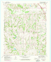
1969 Map of Elmore City NE
USGS Topo · Published 1988About this map
Rush Creek meanders through the northern portion of this Oklahoma landscape, defining a topography heavily marked by the region's energy and agricultural activities. The transition between the Whitebead, Elmore, and Brady districts reveals a countryside dotted with numerous oil wells and a complex network of pipelines that crisscross the terrain. This late 1960s survey, updated with aerial data in the late 1970s, captures the rural social fabric through landmarks such as Love Ch, Fair Oak Ch, and the Church of God. The A T & S F railroad cuts through the northeastern corner, providing a vital link for the local economy. Water management is evident through a series of reservoirs and spillways, including Spillway Elev 1010 and Spillway Elev 918, which sit amidst the hills south of the creek.
Find a feature on this map
20 named features on this map. Tap any name to fly to it.
Don’t see what you’re looking for? This feature index may not catch every label — zoom into the map to look around manually.
Map Details
Editions of this 1969 Elmore City NE Map
3 editions found
Other maps of this area

1898 · Pauls Valley
USGS Topo · 1:125,000

1902 · Pauls Valley
USGS Topo · 1:125,000

1957 · Ardmore
USGS Topo · 1:250,000

1963 · Ardmore
USGS Topo · 1:250,000

1965 · Byars SW
USGS Topo · 1:24,000

1965 · Pauls Valley
USGS Topo · 1:24,000

1965 · Maysville
USGS Topo · 1:24,000

1965 · Joy
USGS Topo · 1:24,000

1965 · Paoli
USGS Topo · 1:24,000

1969 · Hennepin
USGS Topo · 1:24,000