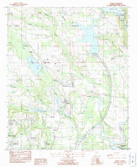
1987 Map of Elmore
USGS Topo · Published 1987About this map
The Coosa River defines the landscape of this 1980s survey, where hydroelectric power and local agriculture meet. The northern reaches are dominated by Jordan Lake and the Walter Bouldin Dam, which control the river's flow near Riverside Ch and Jordan Dam. The CSX rail line provides a central corridor through the region, connecting the small community of Speigner and its namesake Speigner Lake with the growing hubs of Elmore and North Elmore.
Find a feature on this map
49 named features on this map. Tap any name to fly to it.
Don’t see what you’re looking for? This feature index may not catch every label — zoom into the map to look around manually.
Map Details
Editions of this 1987 Elmore Map
2 editions found
Other maps of this area

1901 · Wetumpka
USGS Topo · 1:125,000

1901 · Wetumpka
USGS Topo · 1:62,500

1903 · Wetumpka
USGS Topo · 1:125,000

1927 · Montgomery
USGS Topo · 1:48,000

1930 · Montgomery
USGS Topo · 1:62,500

1953 · Montgomery
USGS Topo · 1:250,000

1956 · Montgomery
USGS Topo · 1:250,000

1957 · Montgomery
USGS Topo · 1:250,000

1958 · Montgomery
USGS Topo · 1:62,500

1958 · Montgomery North
USGS Topo · 1:24,000