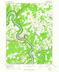
1963 Map of Emlenton
USGS Topo · Published 1965About this map
The Allegheny River carves a deep, sinuous path through this 1963 landscape, meeting the Clarion River near Foxburg. This confluence serves as a nexus for the Pennsylvania and Baltimore and Ohio railroads, which track the riverbanks to serve the region's industrial interests. The map reveals an extensive Oil Field spanning much of the uplands, interspersed with numerous strip mines that mark the mid-century extraction economy of the Venango, Butler, and Clarion county borders.
Find a feature on this map
45 named features on this map. Tap any name to fly to it.
Don’t see what you’re looking for? This feature index may not catch every label — zoom into the map to look around manually.
Map Details
Editions of this 1963 Emlenton Map
4 editions found
Other maps of this area

1907 · Foxburg
USGS Topo · 1:62,500

1908 · Foxburg
USGS Topo · 1:62,500

1909 · Franklin
USGS Topo · 1:62,500

1910 · Hilliards
USGS Topo · 1:62,500

1911 · Franklin
USGS Topo · 1:62,500

1912 · Hilliards
USGS Topo · 1:62,500

1922 · Oil City
USGS Topo · 1:48,000

1924 · Oil City
USGS Topo · 1:62,500

1943 · Oil City
USGS Topo · 1:62,500

1944 · Hilliards
USGS Topo · 1:62,500