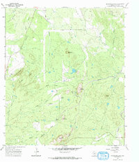
1967 Map of Enchanted Rock
USGS Topo · Published 1970About this map
Enchanted Rock stands as the prominent landmark of this Central Texas landscape, situated at the confluence of several watercourses including Sandy Creek and Walnut Spring Creek. The 1967 survey reveals a rural terrain marked by family-named peaks and vital water sources such as Honey Spring and Walnut Spring. Traces of local history are visible in the placement of the Rossberg Cem and Moss Cem, while the Etheridge Landing Strip indicates modern accessibility into this pocket of the Hill Country. The presence of numerous Prospects and a Goldmine Creek suggest a history of mineral exploration throughout the creek-fed valleys. This environment is characterized by its high concentrations of drainage systems like North Helms Creek and South Helms Creek, illustrating a well-watered cattle and ranching region before major development arrived.
Find a feature on this map
31 named features on this map. Tap any name to fly to it.
Don’t see what you’re looking for? This feature index may not catch every label — zoom into the map to look around manually.
Map Details
Editions of this 1967 Enchanted Rock Map
2 editions found
Other maps of this area

1887 · Llano
USGS Topo · 1:125,000

1894 · Fredericksburg
USGS Topo · 1:125,000

1894 · Llano
USGS Topo · 1:125,000

1904 · Llano
USGS Topo · 1:125,000

1909 · Llano
USGS Topo · 1:125,000

1918 · Llano
USGS Topo · 1:125,000

1954 · Llano
USGS Topo · 1:250,000

1955 · Llano
USGS Topo · 1:250,000

1956 · Llano
USGS Topo · 1:250,000
1960 · Scotts Crossing
USGS Topo · 1:24,000