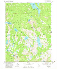
1983 Map of English Mtn
USGS Topo · Published 1983About this map
Summit City and Baltimore Town appear as ghost town sites in the high Sierra of the early 1980s, marking the remains of gold-rush era settlements within the Tahoe National Forest. The landscape is defined by its complex hydrology, dominated by the massive Jackson Meadows Reservoir and the Bowman Lake spillway. Traces of the historic Henness Pass Road cut through the northern terrain, following a corridor once vital for trans-Sierra trade and migration.
Find a feature on this map
82 named features on this map. Tap any name to fly to it.
Don’t see what you’re looking for? This feature index may not catch every label — zoom into the map to look around manually.
Map Details
Editions of this 1983 English Mtn Map
3 editions found
Other maps of this area

1890 · Sierraville
USGS Topo · 1:125,000

1891 · Downieville
USGS Topo · 1:125,000

1891 · Colfax
USGS Topo · 1:125,000

1891 · Truckee
USGS Topo · 1:125,000

1892 · Sierraville
USGS Topo · 1:125,000

1892 · Colfax
USGS Topo · 1:125,000

1893 · Truckee
USGS Topo · 1:125,000

1893 · Downieville
USGS Topo · 1:125,000

1894 · Colfax
USGS Topo · 1:125,000

1894 · Sierraville
USGS Topo · 1:125,000