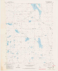
1983 Map of English Mtn
USGS Topo · Published 1983About this map
Baltimore Town (Site) and Summit City (Site) anchor this high-altitude landscape of the northern Sierra Nevada, representing the legacy of ephemeral mining boomtowns within the Tahoe National Forest. By the mid-1970s, when these field checks were performed, the region had transitioned from hard-rock mining at sites like Excelsior Mine to a major water-management hub. Significant reservoirs like Jackson Meadows Reservoir, Bowman Lake, and French Lake dominate the terrain, connected by rugged routes like Meadow Lake Road. The presence of the Pacific Crest National Scenic Trail winding through the granite basins near English Mtn and Black Buttes highlights the area's mid-century importance for recreation. Genealogists and historians can trace old livestock operations at Churchs Camp Corral or locate survey markers such as the Bent Monument on the county line.
Find a feature on this map
82 named features on this map. Tap any name to fly to it.
Don’t see what you’re looking for? This feature index may not catch every label — zoom into the map to look around manually.
Map Details
Editions of this 1983 English Mtn Map
3 editions found
Other maps of this area

1890 · Sierraville
USGS Topo · 1:125,000

1891 · Downieville
USGS Topo · 1:125,000

1891 · Colfax
USGS Topo · 1:125,000

1891 · Truckee
USGS Topo · 1:125,000

1892 · Sierraville
USGS Topo · 1:125,000

1892 · Colfax
USGS Topo · 1:125,000

1893 · Truckee
USGS Topo · 1:125,000

1893 · Downieville
USGS Topo · 1:125,000

1894 · Colfax
USGS Topo · 1:125,000

1894 · Sierraville
USGS Topo · 1:125,000