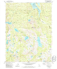
1983 Map of English Mtn
USGS Topo · Published 1986About this map
The Tahoe National Forest high country is defined by a dense network of glacial lakes and reservoirs, captured here in the mid-1970s. The landscape is a study in resource management and mining history, notably preserving the locations of former settlements like Summit City (Site) and Baltimore Town (Site) near the eastern edge. Industrial activity is further evidenced by the Excelsior Mine and scattered prospects that dot the terrain between French Lake and Meadow Lake.
Find a feature on this map
74 named features on this map. Tap any name to fly to it.
Don’t see what you’re looking for? This feature index may not catch every label — zoom into the map to look around manually.
Map Details
Editions of this 1983 English Mtn Map
3 editions found
Other maps of this area

1890 · Sierraville
USGS Topo · 1:125,000

1891 · Downieville
USGS Topo · 1:125,000

1891 · Colfax
USGS Topo · 1:125,000

1891 · Truckee
USGS Topo · 1:125,000

1892 · Sierraville
USGS Topo · 1:125,000

1892 · Colfax
USGS Topo · 1:125,000

1893 · Truckee
USGS Topo · 1:125,000

1893 · Downieville
USGS Topo · 1:125,000

1894 · Colfax
USGS Topo · 1:125,000

1894 · Sierraville
USGS Topo · 1:125,000