1990 Map of Enid
USGS Topo · Published 1990About this map
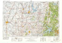
Vance Air Force Base stands as a prominent fixture of the landscape just south of Enid, anchoring a region defined by extensive Oil and Gas Fields and a geometric grid of rural roads. This 1990 revision reflects the infrastructure of north-central Oklahoma as it stood in the late twentieth century, showing the connectivity between the regional hubs of Perry and Stillwater via the Cimarron Turnpike. The drainage of the Arkansas River and Cimarron River systems is marked by significant reservoirs like Lake Carl Blackwell and Sooner Lake, which support both local recreation and industrial needs. Smaller agricultural communities such as Hennessey, Waukomis, and Breckinridge are mapped in detail, providing a clear view of the settlement patterns that evolved around the area's energy and aviation sectors.
Find a feature on this map
55 named features on this map. Tap any name to fly to it.
Don’t see what you’re looking for? This feature index may not catch every label — zoom into the map to look around manually.
Map Details
Editions of this 1990 Enid Map
This is the sole edition of this map. No revisions or reprints were ever made.
Historical Maps of Enid Through Time
4 maps found