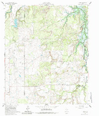
1961 Map of Eolian
USGS Topo · Published 1985About this map
The Shackelford Co Stephens Co border runs through this West Texas landscape, dominated by the drainage basins of Hubbard Creek and Sandy Creek. This early 1960s survey documents the area just as the West Central Texas Municipal Water District was preparing for major changes, indicated by blue hatching that shows land soon to be submerged by Hubbard Creek Lake. The rural settlement of Eolian stands near the center of the sheet, while genealogists can find localized history at Plum Branch Cem, Shady Grove Cem, and Battle Creek Cem. Historical industry is represented by the Mankins Mill (Site) near Bear Branch, and the varied terrain is carved by numerous seasonal waterways including Dry Branch, Meeks Branch, and Brushy Creek.
Find a feature on this map
18 named features on this map. Tap any name to fly to it.
Don’t see what you’re looking for? This feature index may not catch every label — zoom into the map to look around manually.
Map Details
Editions of this 1961 Eolian Map
3 editions found
Other maps of this area

1890 · Breckenridge
USGS Topo · 1:125,000

1892 · Albany
USGS Topo · 1:125,000

1893 · Albany
USGS Topo · 1:125,000

1954 · Abilene
USGS Topo · 1:250,000

1958 · Abilene
USGS Topo · 1:250,000

1958 · Breckenridge
USGS Topo · 1:24,000

1958 · Edwards Branch
USGS Topo · 1:24,000

1961 · Buck Mountain
USGS Topo · 1:24,000

1961 · Eolian
USGS Topo · 1:24,000

1965 · McCatherine Mountain
USGS Topo · 1:24,000