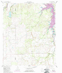
1961 Map of Eolian
USGS Topo · Published 1987About this map
Hubbard Creek Lake dominates the upper reaches of this West Texas landscape, where the boundary between Shackleford and Stephens counties cuts through a series of creek-fed basins. The 1961 data, updated with 1980s aerial revisions, shows a region transitioning between ranching, water management, and the energy industry. Local history is anchored by the small settlement of Eolian and the community center at Shady Grove, with genealogical details preserved at Plum Branch Cem, Shady Grove Cem, and Battle Creek Cem.
Find a feature on this map
26 named features on this map. Tap any name to fly to it.
Don’t see what you’re looking for? This feature index may not catch every label — zoom into the map to look around manually.
Map Details
Editions of this 1961 Eolian Map
3 editions found
Other maps of this area

1890 · Breckenridge
USGS Topo · 1:125,000

1892 · Albany
USGS Topo · 1:125,000

1893 · Albany
USGS Topo · 1:125,000

1954 · Abilene
USGS Topo · 1:250,000

1958 · Abilene
USGS Topo · 1:250,000

1958 · Breckenridge
USGS Topo · 1:24,000

1958 · Edwards Branch
USGS Topo · 1:24,000

1961 · Buck Mountain
USGS Topo · 1:24,000

1961 · Eolian
USGS Topo · 1:24,000

1965 · McCatherine Mountain
USGS Topo · 1:24,000