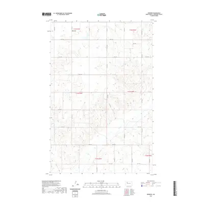
2020 Map of Epworth
USGS Topo · Published 2020About this map
Epworth sits in the northern section of this Mountrail County landscape, where the high prairie begins its descent into the drainage of Shell Cr. This 2020 survey illustrates a quintessential North Dakota section-line grid, defined by a series of numbered roads from 48th St NW down to 41st St NW. The terrain is characterized by the intricate coulees and draws that feed the creek system, creating a textured topography that breaks the geometric regularity of the surveyed townships. For those researching local burial sites or land ownership, Johns Cem remains a primary landmark in the northeastern reaches of the quadrangle. The map captures the enduring rural character of the region, showing the persistent relationship between the prairie's natural hydrology and the established township and range system.
Find a feature on this map
17 named features on this map. Tap any name to fly to it.
Don’t see what you’re looking for? This feature index may not catch every label — zoom into the map to look around manually.
Map Details
Editions of this 2020 Epworth Map
This is the sole edition of this map. No revisions or reprints were ever made.
Other maps of this area

1953 · Williston
USGS Topo · 1:250,000

1953 · Watford City
USGS Topo · 1:250,000

1957 · Williston
USGS Topo · 1:250,000

1957 · Watford City
USGS Topo · 1:250,000

1967 · Watford City
USGS Topo · 1:250,000
1981 · Parshall NE
USGS Topo · 1:24,000
1981 · Epworth SE
USGS Topo · 1:24,000
1981 · Belden SE
USGS Topo · 1:24,000
1981 · Shell Lake
USGS Topo · 1:24,000
1981 · Parshall
USGS Topo · 1:24,000