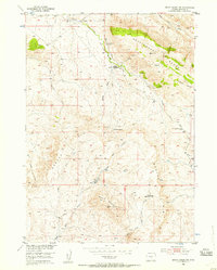
1952 Map of Ervay Basin SW
USGS Topo · Published 1957About this map
Holiday Homestead and the Aspell Homestead Site stand as quiet evidence of high-plains settlement in this pocket of Natrona County during the early 1950s. Located along the Asbell Road, these sites are positioned near the transition from the high Beaver Rim down toward the drainage of Sage Hen Creek. The landscape is dominated by the massive uplifting of the Rattlesnake Range in the northeast and Black Mountain to the south, creating a complex terrain of canyons and divides.
Find a feature on this map
26 named features on this map. Tap any name to fly to it.
Don’t see what you’re looking for? This feature index may not catch every label — zoom into the map to look around manually.
Map Details
Editions of this 1952 Ervay Basin SW Map
3 editions found
Other maps of this area

1952 · Ervay Basin SW
USGS Topo · 1:24,000

1952 · Gas Hills
USGS Topo · 1:24,000

1952 · Miles Ranch
USGS Topo · 1:24,000

1952 · Ervay Basin
USGS Topo · 1:24,000

1952 · Mc Intosh Meadows
USGS Topo · 1:24,000

1955 · Casper
USGS Topo · 1:250,000

1957 · Miles Ranch
USGS Topo · 1:24,000

1958 · Casper
USGS Topo · 1:250,000
1958 · Gas Hills
USGS Topo · 1:24,000
1959 · Mc Rae Gap
USGS Topo · 1:24,000