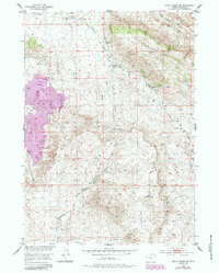
1952 Map of Ervay Basin SW
USGS Topo · Published 1985About this map
The Rattlesnake Hills and Black Mountain dominate this landscape within Natrona County, where early-to-mid 20th-century ranching and transit infrastructure shaped the high desert terrain. The presence of the Holiday Homestead (Aband) and the Asbell Homestead Site reflects the legacy of individual land claims in the Beaver Divide region. Historic transportation routes are well-defined, including the Poison Spider Road and the Freight Road, which likely supported livestock movement and logistics between isolated outposts like the Strawbaker Corral. Water management, critical for survival in this environment, is evidenced by Boyle Reservoir and numerous named water sources such as McKenzie Spring and Little Cross L Spring. A Landing Strip and a Pipeline represent the gradual integration of modern industrial and aviation facilities into the remote basin during the post-war era.
Find a feature on this map
23 named features on this map. Tap any name to fly to it.
Don’t see what you’re looking for? This feature index may not catch every label — zoom into the map to look around manually.
Map Details
Editions of this 1952 Ervay Basin SW Map
3 editions found
Other maps of this area

1952 · Ervay Basin SW
USGS Topo · 1:24,000

1952 · Gas Hills
USGS Topo · 1:24,000

1952 · Miles Ranch
USGS Topo · 1:24,000

1952 · Ervay Basin
USGS Topo · 1:24,000

1952 · Mc Intosh Meadows
USGS Topo · 1:24,000

1955 · Casper
USGS Topo · 1:250,000

1957 · Miles Ranch
USGS Topo · 1:24,000

1958 · Casper
USGS Topo · 1:250,000
1958 · Gas Hills
USGS Topo · 1:24,000
1959 · Mc Rae Gap
USGS Topo · 1:24,000