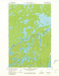
1959 Map of Ester Lake
USGS Topo · Published 1981About this map
Quetico Provincial Park and the Superior National Forest dominate this borderland landscape, where the international boundary between Ontario and Minnesota bisects a complex network of glacial waterways. The 1958-1959 survey records a wilderness environment defined by portages and traditional water routes, such as the Swamp Portage connecting Swamp Lake and Cypress Lake. This era represents a period before modern water management significantly altered the flow of these remote basins, preserving the original paths used by early travelers. The map traces the rugged connection between Hunter Island and the mainland, highlighting the transition from Canadian waters like Saganagons Lake to American basins such as Ester Lake and the aptly named Lake of the Clouds. Local topography is marked by notable elevation changes, including the High Falls on the Canadian side, and several identified Rapids along the river systems.
Find a feature on this map
63 named features on this map. Tap any name to fly to it.
Don’t see what you’re looking for? This feature index may not catch every label — zoom into the map to look around manually.
Map Details
Editions of this 1959 Ester Lake Map
4 editions found
Other maps of this area

1957 · Quetico
USGS Topo · 1:250,000

1959 · Munker Island
USGS Topo · 1:24,000

1959 · Ogishkemuncie Lake
USGS Topo · 1:24,000

1959 · Kekekabic Lake
USGS Topo · 1:24,000

1959 · Dutton Lake
USGS Topo · 1:24,000

1959 · Gillis Lake
USGS Topo · 1:24,000

1959 · Ester Lake
USGS Topo · 1:24,000

1968 · Quetico
USGS Topo · 1:250,000

1976 · Saganaga Lake
USGS Topo · 1:100,000

1977 · Basswood Lake
USGS Topo · 1:100,000