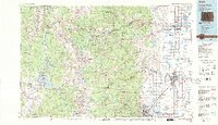
1984 Map of Estes Park
USGS Topo · Published 1984About this map
Rocky Mountain National Park and the rugged Continental Divide dominate the western half of this mid-1980s landscape, while the agricultural and urban corridor of the Front Range unfolds to the east. The map captures the dramatic transition from high alpine summits like Longs Peak down through the Big Thompson River canyon to the settled plains. In the eastern valley, the established communities of Longmont, Boulder, and Loveland show their late-century footprints, connected by an active transport network including the Union Pacific RR and Great Western RR. High-altitude water management is evident in the Arapaho National Recreation Area, where Lake Granby and Shadow Mountain Lake serve as massive reservoirs. Smaller, historic mining settlements like Gold Hill, Ward, and Jamestown remain tucked into the foothills, providing a clear record of the region's extraction-based origins and subsequent transition to a recreation-heavy economy anchored by Estes Park.
Find a feature on this map
106 named features on this map. Tap any name to fly to it.
Don’t see what you’re looking for? This feature index may not catch every label — zoom into the map to look around manually.
Map Details
Editions of this 1984 Estes Park Map
3 editions found
Other maps of this area

1890 · East Denver
USGS Topo · 1:125,000

1899 · West Denver
USGS Topo · 1:125,000

1902 · Greeley
USGS Topo · 1:125,000

1902 · Boulder
USGS Topo · 1:62,500

1904 · Niwot
USGS Topo · 1:62,500

1904 · Boulder
USGS Topo · 1:62,500

1905 · Central City
USGS Topo · 1:62,500

1905 · Mount Olympus
USGS Topo · 1:62,500

1906 · Blackhawk
USGS Topo · 1:62,500

1906 · Loveland
USGS Topo · 1:62,500