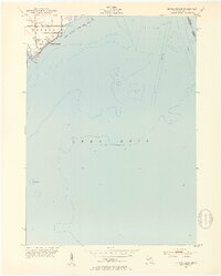
1952 Map of Estral Beach
USGS Topo · Published 1953About this map
Estral Beach sits on the western shore of Lake Erie in the early 1950s, serving as a concentrated residential hub amidst the marshy transitions of the Monroe County coastline. The township boundary between Berlin and Frenchtown cuts through the area just south of Swan Creek, which empties into the lake near several small offshore structures. To the north, the Pointe Mouillee State Game Area preserves the wetland character of the shoreline, defined by levees and drainage channels. Navigational details such as a Submerged Wreck and the international boundary between the United States and Canada highlight the maritime importance of this stretch of water. Local transit is facilitated by Masserant Rd and Port Sunlight Road, which connect the beach community to the inland agricultural and industrial corridors of Southeast Michigan.
Find a feature on this map
15 named features on this map. Tap any name to fly to it.
Don’t see what you’re looking for? This feature index may not catch every label — zoom into the map to look around manually.
Map Details
Editions of this 1952 Estral Beach Map
2 editions found
Other maps of this area

1906 · Wyandotte
USGS Topo · 1:62,500

1906 · Romulus
USGS Topo · 1:62,500

1912 · Wyandotte
USGS Topo · 1:62,500

1912 · Monroe
USGS Topo · 1:62,500

1914 · Monroe
USGS Topo · 1:62,500

1928 · Romulus
USGS Topo · 1:62,500

1929 · Wyandotte
USGS Topo · 1:62,500

1936 · Rockwood
USGS Topo · 1:31,680

1936 · Stony Point
USGS Topo · 1:31,680
1936 · Flat Rock
USGS Topo · 1:31,680
Featured Places
- Frenchtown Charter Township, MI
- Berlin Charter Township, MI
- Estral Beach, Berlin Charter Township
- Lucas County, OH