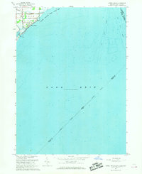
1967 Map of Estral Beach
USGS Topo · Published 1969About this map
Estral Beach sits on the western edge of Lake Erie in this coastal survey, where the terrestrial landscape of Monroe County meets the open water and navigational corridors of the Great Lakes. The map illustrates a transitional environment, with the Pointe Mouillee State Game Area dominating the northern shoreline. Inland, the small settlement of Langton and a grid of local roads like Masserant Rd provide evidence of rural development just behind the marshes. Most of the sheet is dedicated to the lake itself, documenting deep-water features including the West Outer Channel and East Outer Channel. These shipping lanes, combined with the complex jurisdictional web of the Michigan-Ohio state line and the international United States-Canada boundary, reflect the area's importance as a maritime transit point during the late 1960s.
Find a feature on this map
16 named features on this map. Tap any name to fly to it.
Don’t see what you’re looking for? This feature index may not catch every label — zoom into the map to look around manually.
Map Details
Editions of this 1967 Estral Beach Map
2 editions found
Other maps of this area

1906 · Wyandotte
USGS Topo · 1:62,500

1906 · Romulus
USGS Topo · 1:62,500

1912 · Wyandotte
USGS Topo · 1:62,500

1912 · Monroe
USGS Topo · 1:62,500

1914 · Monroe
USGS Topo · 1:62,500

1928 · Romulus
USGS Topo · 1:62,500

1929 · Wyandotte
USGS Topo · 1:62,500

1936 · Rockwood
USGS Topo · 1:31,680

1936 · Stony Point
USGS Topo · 1:31,680
1936 · Flat Rock
USGS Topo · 1:31,680
Featured Places
- Frenchtown Charter Township, MI
- Berlin Charter Township, MI
- Estral Beach, Berlin Charter Township
- Lucas County, OH