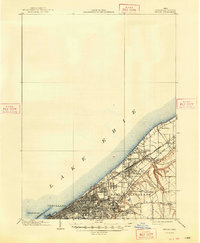
1903 Map of Euclid
USGS Topo · Published 1948About this map
Industrial and residential expansion defines the shoreline of Lake Erie at the turn of the twentieth century. The map highlights the significant rail corridors serving the region, including the Southern, St. Louis, and Michigan and the New York Chicago and lines. These transit arteries supported the growth of dense settlements like Collinwood, Nottingham, and East Cleveland. Along the waterfront, the Waterworks Crib and Breakwater illustrate the civil engineering required to support the burgeoning city of Cleveland.
Find a feature on this map
31 named features on this map. Tap any name to fly to it.
Don’t see what you’re looking for? This feature index may not catch every label — zoom into the map to look around manually.
Map Details
Editions of this 1903 Euclid Map
2 editions found
Other maps of this area

1901 · Euclid
USGS Topo · 1:62,500

1902 · Berea
USGS Topo · 1:62,500

1903 · Cleveland
USGS Topo · 1:62,500

1903 · Euclid
USGS Topo · 1:62,500

1904 · Berea
USGS Topo · 1:62,500

1905 · Mentor
USGS Topo · 1:62,500

1906 · Chagrin Falls
USGS Topo · 1:62,500

1907 · Mentor
USGS Topo · 1:62,500

1908 · Chagrin Falls
USGS Topo · 1:62,500

1950 · Cleveland
USGS Topo · 1:250,000