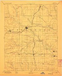
1894 Map of Eureka
USGS Topo · Published 1906About this map
Eureka serves as the central hub of this late 19th-century landscape, where several major rail lines converged to move cattle and grain across the Kansas prairie. The Missouri Pacific Railroad and the Atchison Topeka and Santa Fe Railroad intersect near the town, illustrating the vital role of transportation in the settlement of Greenwood County. Along the winding course of the Fall River, small communities like Climax and Twin Falls mark the transition from the rolling uplands to the river valleys. The topography is defined by numerous watercourses including Slate Creek and Honey Creek, which provided essential resources for early homesteads such as Western Park and Cave Springs. These interior settlements and the network of township boundaries like Paw Paw and Lane reveal the structured expansion of agricultural life before the turn of the century.
Find a feature on this map
71 named features on this map. Tap any name to fly to it.
Don’t see what you’re looking for? This feature index may not catch every label — zoom into the map to look around manually.
Map Details
Editions of this 1894 Eureka Map
5 editions found

Other maps of this area

1885 · Burlington
USGS Topo · 1:125,000

1885 · Eureka
USGS Topo · 1:125,000

1885 · Sedan
USGS Topo · 1:125,000

1886 · Fredonia
USGS Topo · 1:125,000

1886 · Independence
USGS Topo · 1:125,000

1888 · Emporia
USGS Topo · 1:125,000

1888 · Eureka
USGS Topo · 1:125,000

1888 · Eldorado
USGS Topo · 1:125,000

1889 · Burden
USGS Topo · 1:125,000

1889 · Sedan
USGS Topo · 1:125,000