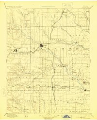
1894 Map of Eureka
USGS Topo · Published 1925About this map
The Eureka settlement serves as the central hub of this late-nineteenth-century Kansas landscape, where the iron rails of three major systems converge. The Atchison Topeka and Santa Fe Railroad Howard Br. runs north to south through the center, intersecting with the Missouri Pacific Railroad (F. S. W. & W. Br.) at the county seat. In the south, the St. Louis and San Francisco Railroad carves a path through Piedmont and Severy, establishing a critical transportation network for the region's agricultural economy.
Find a feature on this map
68 named features on this map. Tap any name to fly to it.
Don’t see what you’re looking for? This feature index may not catch every label — zoom into the map to look around manually.
Map Details
Editions of this 1894 Eureka Map
5 editions found

Other maps of this area

1885 · Burlington
USGS Topo · 1:125,000

1885 · Eureka
USGS Topo · 1:125,000

1885 · Sedan
USGS Topo · 1:125,000

1886 · Fredonia
USGS Topo · 1:125,000

1886 · Independence
USGS Topo · 1:125,000

1888 · Emporia
USGS Topo · 1:125,000

1888 · Eureka
USGS Topo · 1:125,000

1888 · Eldorado
USGS Topo · 1:125,000

1889 · Burden
USGS Topo · 1:125,000

1889 · Sedan
USGS Topo · 1:125,000