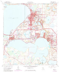
1966 Map of Eustis
USGS Topo · Published 1984About this map
The central Florida citrus belt and the connected waters of the Harris Chain of Lakes define this mid-1960s landscape. Eustis sits prominently at the north, its residential streets reaching toward Trout Lake and Lake Gracie, while the county seat of Tavares occupies the narrow land bridge between Lake Eustis and Lake Dora. The Seaboard Coast Line railroad creates a vital corridor through the region, passing through Ellsworth Junction and providing a backbone for the developing towns.
Find a feature on this map
76 named features on this map. Tap any name to fly to it.
Don’t see what you’re looking for? This feature index may not catch every label — zoom into the map to look around manually.
Map Details
Editions of this 1966 Eustis Map
3 editions found
Other maps of this area

1955 · Orlando
USGS Topo · 1:250,000

1957 · Orlando
USGS Topo · 1:250,000

1958 · Orlando
USGS Topo · 1:250,000

1960 · Sorrento
USGS Topo · 1:24,000

1960 · Apopka
USGS Topo · 1:24,000

1962 · Orlando
USGS Topo · 1:250,000

1962 · Astatula
USGS Topo · 1:24,000

1965 · Leesburg East
USGS Topo · 1:24,000

1965 · Umatilla
USGS Topo · 1:24,000
1965 · Paisley
USGS Topo · 1:24,000