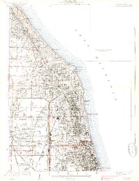
1928 Map of Evanston
USGS Topo · Published 1939About this map
Northwestern University and Loyola University anchor the Lake Michigan shoreline in this study of the northern Chicago suburbs during the late 1930s. The landscape is defined by the rigid grid of growing residential districts and the massive infrastructure required for an expanding metropolitan population, most notably the North Shore Channel and the North Side Sewage Treatment Works. The map captures the distinct character of the North Shore communities, from the dense blocks of Evanston to the established neighborhoods of Winnetka, Kenilworth, and Wilmette. A significant historical remnant, the Old Indian Bdy, cuts diagonally across the township lines near Niles Center. Golf culture is prominent across the interior, shown through the sprawling grounds of the Onwentsia Country Club and Westmoreland Golf Club, while the coast features the Gross Pt LH and the Sheridan Road Yacht Club at Wilmette Harbor.
Find a feature on this map
63 named features on this map. Tap any name to fly to it.
Don’t see what you’re looking for? This feature index may not catch every label — zoom into the map to look around manually.
Map Details
Editions of this 1928 Evanston Map
5 editions found

Other maps of this area

1889 · Chicago
USGS Topo · 1:62,500

1891 · Chicago
USGS Topo · 1:62,500

1891 · Riverside
USGS Topo · 1:62,500

1893 · Riverside
USGS Topo · 1:62,500

1899 · Evanston
USGS Topo · 1:62,500

1900 · Chicago
USGS Topo · 1:62,500

1900 · Riverside
USGS Topo · 1:62,500

1900 · Highwood
USGS Topo · 1:62,500

1901 · Riverside
USGS Topo · 1:62,500

1901 · Chicago
USGS Topo · 1:62,500