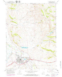
1965 Map of Evanston
USGS Topo · Published 1979About this map
The railroad hub of Evanston serves as the focal point of this 1960s survey, updated in the late 1970s. The town's industrial and civic footprint is clearly defined by the Union Pacific tracks, the State Hosp, and the local Fairground. The landscape transitions from the urban center to the surrounding Wyoming high country, characterized by numerous drainages like Dry Canyon and Limekiln Gulch. Water management is prominent through features like the Crompton Reservoir and the Aqueduct, supporting the community alongside the winding Bear River. Genealogists and local historians will find significant value in the detailed layout of the local Cemetery and the residential expansion near Hamblin Park. Traces of the region's earlier travel routes are visible in the Old Rocky Mountain Road, which contrasts with the modern developments of the Evanston Municipal Airport and emerging Pipelines.
Find a feature on this map
47 named features on this map. Tap any name to fly to it.
Don’t see what you’re looking for? This feature index may not catch every label — zoom into the map to look around manually.
Map Details
Editions of this 1965 Evanston Map
3 editions found
Other maps of this area

1954 · Ogden
USGS Topo · 1:250,000

1958 · Ogden
USGS Topo · 1:250,000

1960 · Ogden
USGS Topo · 1:250,000

1965 · Evanston
USGS Topo · 1:24,000

1965 · Little Dee Creek
USGS Topo · 1:24,000

1965 · Sulphur Creek Reservoir
USGS Topo · 1:24,000

1965 · Guild Hollow
USGS Topo · 1:24,000

1965 · Three Forks
USGS Topo · 1:24,000

1965 · Millis
USGS Topo · 1:24,000

1968 · Wahsatch
USGS Topo · 1:24,000