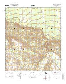
2013 Map of Fairbanks A-3 NW
USGS Topo · Published 2013About this map
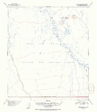
Tatlanika Cr cuts through this interior landscape, providing a primary drainage route for the surrounding high-elevation terrain. The map depicts a transitional area where the northern lowlands meet the significant rising contours of the Alaska Range foothills. Navigation and access across this remote territory are limited to a single, established Sled Rd, which traverses the northern half of the sheet. This transport corridor represents the sparse but critical human infrastructure used for winter movement through the Denali region. The survey highlights the intersection of Township 8 South and Township 9 South, illustrating the systematic Public Land Survey System grid as it was applied to the rugged and largely undeveloped Alaskan wilderness during the early twenty-first century.
Find a feature on this map
4 named features on this map. Tap any name to fly to it.
Don’t see what you’re looking for? This feature index may not catch every label — zoom into the map to look around manually.
Map Details
Editions of this 2013 Fairbanks A-3 NW Map
This is the sole edition of this map. No revisions or reprints were ever made.
Other maps of this area

1949 · Fairbanks B-4
USGS Topo · 1:63,360

1949 · Fairbanks B-3
USGS Topo · 1:63,360

1950 · Fairbanks
USGS Topo · 1:250,000

1950 · Fairbanks A-4
USGS Topo · 1:63,360

1950 · Fairbanks A-3
USGS Topo · 1:63,360

1951 · Fairbanks
USGS Topo · 1:250,000
1952 · Fairbanks A-4
USGS Topo · 1:63,360
1952 · Fairbanks A-3
USGS Topo · 1:63,360
1952 · Fairbanks B-4
USGS Topo · 1:63,360
1952 · Fairbanks B-3
USGS Topo · 1:63,360