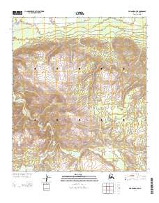
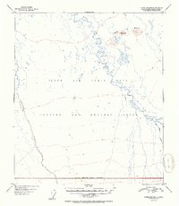
2013 Map of Fairbanks A-4 NE
USGS Topo · Published 2013About this map
Totatlanika River carves a winding path through this interior Alaskan landscape, which remains largely dominated by its natural drainage patterns and steep elevation changes. This 2013 survey by the U.S. Geological Survey captures a region where formal infrastructure is nearly non-existent, defined primarily by the Sled Rd that traverses the northern boundary. The absence of settlements or established highways highlights the isolation of this terrain in the Denali Borough. Near the southern edge, the headwaters of California Cr emerge, feeding into the broader watershed. The map's detail is focused on the complex topography and the survey lines that mark the transition between Townships 8 and 9 South, providing a precise record of this undeveloped wilderness area.
Find a feature on this map
5 named features on this map. Tap any name to fly to it.
Don’t see what you’re looking for? This feature index may not catch every label — zoom into the map to look around manually.
Map Details
Editions of this 2013 Fairbanks A-4 NE Map
This is the sole edition of this map. No revisions or reprints were ever made.
Other maps of this area

1949 · Fairbanks B-4
USGS Topo · 1:63,360

1949 · Fairbanks B-3
USGS Topo · 1:63,360

1950 · Fairbanks
USGS Topo · 1:250,000

1950 · Fairbanks A-4
USGS Topo · 1:63,360

1950 · Fairbanks A-3
USGS Topo · 1:63,360

1951 · Fairbanks
USGS Topo · 1:250,000
1952 · Fairbanks A-4
USGS Topo · 1:63,360
1952 · Fairbanks A-3
USGS Topo · 1:63,360
1952 · Fairbanks B-4
USGS Topo · 1:63,360
1952 · Fairbanks B-3
USGS Topo · 1:63,360