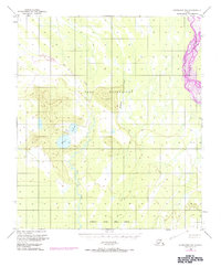
1950 Map of Fairbanks B-1
USGS Topo · Published 1972About this map
Fort Wainwright land dominates the center of this terrain, where military training and aviation infrastructure meet the interior wilderness. The braided channels of the Tanana River cut through the northeastern corner, illustrating the dynamic glacial runoff patterns characteristic of the Fairbanks North Star Borough. Further south, the Blair Lakes basin provides a significant focal point in an otherwise undulating landscape of ridges and wetlands, supported by a remote Landing Strip for bush pilots or military access. The inclusion of Dry Creek and Mc Donald Creek reveals the complex drainage network feeding into the larger river systems. This edition, based on 1949 and 1950 data with 1972 photorevisions, captures the intersection of postwar military expansion and the untouched geography of the Alaskan interior.
Find a feature on this map
9 named features on this map. Tap any name to fly to it.
Don’t see what you’re looking for? This feature index may not catch every label — zoom into the map to look around manually.
Map Details
Editions of this 1950 Fairbanks B-1 Map
4 editions found

Other maps of this area

1949 · Big Delta B-6
USGS Topo · 1:63,360

1949 · Fairbanks C-1
USGS Topo · 1:63,360

1949 · Big Delta C-6
USGS Topo · 1:63,360

1949 · Fairbanks C-2
USGS Topo · 1:63,360

1949 · Big Delta A-6
USGS Topo · 1:63,360

1949 · Fairbanks A-2
USGS Topo · 1:63,360

1949 · Fairbanks A-1
USGS Topo · 1:63,360

1950 · Fairbanks
USGS Topo · 1:250,000

1950 · Big Delta
USGS Topo · 1:250,000

1950 · Fairbanks C-1
USGS Topo · 1:63,360