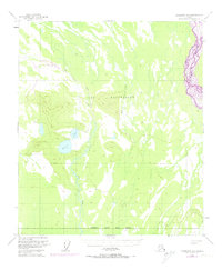
1950 Map of Fairbanks B-1
USGS Topo · Published 1974About this map
The expansive wetlands and braids of the Tanana River dominate the eastern reaches of this interior Alaskan landscape. Mapping based on 1949 aerial photography and 1950 field annotation highlights a transitional wilderness where the northern extent of the Fairbanks North Star Borough meets the military training grounds of Fort Wainwright. The terrain is defined by a network of drainage systems, including Dry Creek and McDonald Creek, which navigate through a complex of low-lying marshes and isolated hills.
Find a feature on this map
7 named features on this map. Tap any name to fly to it.
Don’t see what you’re looking for? This feature index may not catch every label — zoom into the map to look around manually.
Map Details
Editions of this 1950 Fairbanks B-1 Map
4 editions found

Other maps of this area

1949 · Big Delta B-6
USGS Topo · 1:63,360

1949 · Fairbanks C-1
USGS Topo · 1:63,360

1949 · Big Delta C-6
USGS Topo · 1:63,360

1949 · Fairbanks C-2
USGS Topo · 1:63,360

1949 · Big Delta A-6
USGS Topo · 1:63,360

1949 · Fairbanks A-2
USGS Topo · 1:63,360

1949 · Fairbanks A-1
USGS Topo · 1:63,360

1950 · Fairbanks
USGS Topo · 1:250,000

1950 · Big Delta
USGS Topo · 1:250,000

1950 · Fairbanks C-1
USGS Topo · 1:63,360