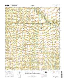
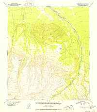
2016 Map of Fairbanks B-3 SE
USGS Topo · Published 2016About this map
The boundary between Denali Borough and the Yukon-Koyukuk Census Area bisects this interior Alaskan landscape, marking a transition between administrative regions in a territory largely defined by its drainage basins. The Wood River flows through the northeastern corner, joined by the headwaters of Gold King Cr, while the winding course of Saint George Cr dominates the central and eastern portions of the sheet. In the west, the upper reaches of Fish Cr cut through the terrain, illustrating the dense network of tributaries that feed the larger river systems of the Tanana Valley region. This 2016 survey documents a wilderness area where human infrastructure is notably absent, replaced by the intricate topographic patterns of the subarctic uplands and the jurisdictional lines that divide the Fairbanks North Star region from its southern neighbors.
Find a feature on this map
16 named features on this map. Tap any name to fly to it.
Don’t see what you’re looking for? This feature index may not catch every label — zoom into the map to look around manually.
Map Details
Editions of this 2016 Fairbanks B-3 SE Map
This is the sole edition of this map. No revisions or reprints were ever made.
Other maps of this area

1949 · Fairbanks B-3
USGS Topo · 1:63,360

1949 · Fairbanks A-2
USGS Topo · 1:63,360

1950 · Fairbanks
USGS Topo · 1:250,000

1950 · Fairbanks A-3
USGS Topo · 1:63,360

1950 · Fairbanks B-2
USGS Topo · 1:63,360
1951 · Fairbanks B-2
USGS Topo · 1:63,360

1951 · Fairbanks
USGS Topo · 1:250,000
1952 · Fairbanks A-3
USGS Topo · 1:63,360
1952 · Fairbanks B-3
USGS Topo · 1:63,360
1952 · Fairbanks A-2
USGS Topo · 1:63,360