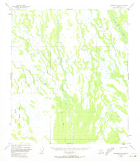
1949 Map of Fairbanks B-4
USGS Topo · Published 1973About this map
Tatlanika River and Tatlanika Creek dominate this landscape south of Fairbanks, flowing through a region defined by extensive marshland and unmapped terrain. Surveyed in 1949 with minor revisions in the early 1970s, the map reveals a remote Alaskan interior largely untouched by permanent settlement or infrastructure. The Winter Trail provides the primary evidence of seasonal transit across the basin, cutting through the northwest and central portions of the sheet. To the southwest, the Clear Military Reservation Boundary marks a significant division in land use, delineating protected military grounds from the surrounding wilderness. The hydrology is intricate, with Fish Creek winding through the western sections, illustrating the complex drainage patterns of the Tanana Valley watershed before modern development altered the region.
Find a feature on this map
5 named features on this map. Tap any name to fly to it.
Don’t see what you’re looking for? This feature index may not catch every label — zoom into the map to look around manually.
Map Details
Editions of this 1949 Fairbanks B-4 Map
5 editions found
Other maps of this area

1949 · Fairbanks B-5
USGS Topo · 1:63,360

1949 · Fairbanks B-4
USGS Topo · 1:63,360

1949 · Fairbanks B-3
USGS Topo · 1:63,360

1950 · Fairbanks
USGS Topo · 1:250,000

1950 · Fairbanks C-3
USGS Topo · 1:63,360

1950 · Fairbanks C-5
USGS Topo · 1:63,360

1950 · Fairbanks A-5
USGS Topo · 1:63,360

1950 · Fairbanks C-4
USGS Topo · 1:63,360

1950 · Fairbanks A-4
USGS Topo · 1:63,360

1950 · Fairbanks A-3
USGS Topo · 1:63,360