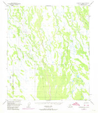
1949 Map of Fairbanks B-4
USGS Topo · Published 1974About this map
The Tatlanika River and Tatlanika Creek dominate this Alaskan landscape, captured during a period of evolving topographic surveillance. The southern portion of the map is defined by the Clear Military Reservation Boundary, reflecting the strategic importance of the interior during the mid-century era. A solitary Winter Trail meanders through the northwest, a vital corridor through the drainage basins of Fish Creek and the surrounding wetlands. This 1949 survey, with revisions added in 1972, highlights the reliance on aerial photography for mapping the remote Tanana Valley region before extensive ground development. The presence of the military boundary indicates the transition from wilderness to federally managed defense zones, while the lack of established road networks underscores the dominance of seasonal trails for traversing the low-lying, water-rich terrain.
Find a feature on this map
6 named features on this map. Tap any name to fly to it.
Don’t see what you’re looking for? This feature index may not catch every label — zoom into the map to look around manually.
Map Details
Editions of this 1949 Fairbanks B-4 Map
5 editions found
Other maps of this area

1949 · Fairbanks B-5
USGS Topo · 1:63,360

1949 · Fairbanks B-4
USGS Topo · 1:63,360

1949 · Fairbanks B-3
USGS Topo · 1:63,360

1950 · Fairbanks
USGS Topo · 1:250,000

1950 · Fairbanks C-3
USGS Topo · 1:63,360

1950 · Fairbanks C-5
USGS Topo · 1:63,360

1950 · Fairbanks A-5
USGS Topo · 1:63,360

1950 · Fairbanks C-4
USGS Topo · 1:63,360

1950 · Fairbanks A-4
USGS Topo · 1:63,360

1950 · Fairbanks A-3
USGS Topo · 1:63,360