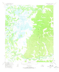
1949 Map of Fairbanks D-4
USGS Topo · Published 1973About this map
The Chatanika River and the vast wetland complex of the Minto Lakes dominate this interior Alaska landscape as it was documented in 1949. This era shows a transition in northern transportation, where The Alaska Railroad cuts through the southern terrain, connecting the small settlement of Dunbar and its Section House to the broader territory. The presence of a Sled Road alongside the rails highlights the reliance on seasonal trails for movement across the marshy lowlands near Goldstream Creek.
Find a feature on this map
22 named features on this map. Tap any name to fly to it.
Don’t see what you’re looking for? This feature index may not catch every label — zoom into the map to look around manually.
Map Details
Editions of this 1949 Fairbanks D-4 Map
5 editions found
Other maps of this area

1945 · Livengood
USGS Topo · 1:250,000

1949 · Fairbanks D-3
USGS Topo · 1:63,360

1949 · Fairbanks D-4
USGS Topo · 1:63,360

1950 · Fairbanks
USGS Topo · 1:250,000

1950 · Fairbanks C-3
USGS Topo · 1:63,360

1950 · Fairbanks C-5
USGS Topo · 1:63,360

1950 · Fairbanks C-4
USGS Topo · 1:63,360

1950 · Fairbanks D-5
USGS Topo · 1:63,360

1950 · Fairbanks D-3
USGS Topo · 1:63,360

1951 · Fairbanks
USGS Topo · 1:250,000