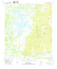
1949 Map of Fairbanks D-4
USGS Topo · Published 1980About this map
Chatanika River and the sprawling Minto Lakes dominate this interior landscape, revealing a remote region defined by its water systems and seasonal transport. In this mid-century environment, human presence is sparse, centered primarily around the infrastructure of The Alaska Railroad at the southern edge. The small settlement of Dunbar and a nearby Section House mark the rail line's passage near Mile 433, providing essential service points in the wilderness.
Find a feature on this map
22 named features on this map. Tap any name to fly to it.
Don’t see what you’re looking for? This feature index may not catch every label — zoom into the map to look around manually.
Map Details
Editions of this 1949 Fairbanks D-4 Map
5 editions found
Other maps of this area

1945 · Livengood
USGS Topo · 1:250,000

1949 · Fairbanks D-3
USGS Topo · 1:63,360

1949 · Fairbanks D-4
USGS Topo · 1:63,360

1950 · Fairbanks
USGS Topo · 1:250,000

1950 · Fairbanks C-3
USGS Topo · 1:63,360

1950 · Fairbanks C-5
USGS Topo · 1:63,360

1950 · Fairbanks C-4
USGS Topo · 1:63,360

1950 · Fairbanks D-5
USGS Topo · 1:63,360

1950 · Fairbanks D-3
USGS Topo · 1:63,360

1951 · Fairbanks
USGS Topo · 1:250,000