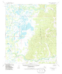
1949 Map of Fairbanks D-4
USGS Topo · Published 1986About this map
Minto Lakes dominate the western lowlands of this Interior Alaska landscape, where a sprawling network of wetlands and small water bodies like Beaver Dam Lake and Wooden Canoe Lake characterize the drainage of Goldstream Creek. The terrain transitions sharply to the east into the rising elevations of the Fairbanks region, marked by ridges such as VABM Luck 2807. This map documents a critical transportation corridor in the mid-20th century, featuring the Alaska Railroad as it skirts the southern hills near the settlement of Dunbar. Evidence of early winter transit is visible in the network of Sled Roads that traverse the marshy flats and follow the Chatanika River valley. Near the center of the sheet, the Indian Cemetery stands as a significant cultural landmark amidst the wilderness, providing essential geographic context for genealogists and local historians studying the Indigenous and pioneer history of the North Star Borough.
Find a feature on this map
24 named features on this map. Tap any name to fly to it.
Don’t see what you’re looking for? This feature index may not catch every label — zoom into the map to look around manually.
Map Details
Editions of this 1949 Fairbanks D-4 Map
5 editions found
Other maps of this area

1945 · Livengood
USGS Topo · 1:250,000

1949 · Fairbanks D-3
USGS Topo · 1:63,360

1949 · Fairbanks D-4
USGS Topo · 1:63,360

1950 · Fairbanks
USGS Topo · 1:250,000

1950 · Fairbanks C-3
USGS Topo · 1:63,360

1950 · Fairbanks C-5
USGS Topo · 1:63,360

1950 · Fairbanks C-4
USGS Topo · 1:63,360

1950 · Fairbanks D-5
USGS Topo · 1:63,360

1950 · Fairbanks D-3
USGS Topo · 1:63,360

1951 · Fairbanks
USGS Topo · 1:250,000