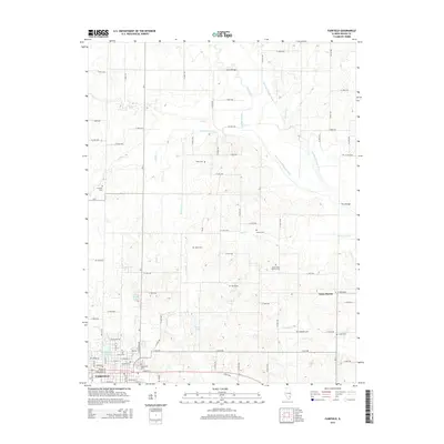
2015 Map of Fairfield
USGS Topo · Published 2015About this map
The county seat of Fairfield anchors the southwestern corner of this Wayne County landscape, where the town's grid meets a sprawling network of rural section roads and water management features. The area north and east of town is defined by a series of north-south running waterways, including Pilcher Cr, Polecat Cr, and the Elm River. These are joined by engineered drainage systems like the Little Elm Lateral and Gerber Lateral, which facilitate agriculture across the flatlands. For genealogists, the map reveals a high density of rural burial grounds such as Buckeye Cem and Posey Cem, many of which appear to be the final resting places of early farming families. Near the center of the sheet, Toms Prairie stands out as a distinct geographic area, flanked by South Toms Prairie Cem and water bodies like Cullum Lake.
Find a feature on this map
100 named features on this map. Tap any name to fly to it.
Don’t see what you’re looking for? This feature index may not catch every label — zoom into the map to look around manually.
Map Details
Editions of this 2015 Fairfield Map
This is the sole edition of this map. No revisions or reprints were ever made.
Other maps of this area

1943 · Albion
USGS Topo · 1:62,500

1946 · Albion
USGS Topo · 1:62,500

1948 · Fairfield
USGS Topo · 1:62,500

1948 · Flora
USGS Topo · 1:62,500

1949 · Olney
USGS Topo · 1:62,500

1949 · Flora
USGS Topo · 1:62,500

1958 · Belleville
USGS Topo · 1:250,000

1962 · Belleville
USGS Topo · 1:250,000

1970 · Enterprise
USGS Topo · 1:24,000
1970 · Cisne
USGS Topo · 1:24,000