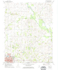
1971 Map of Fairfield
USGS Topo · Published 1973About this map
The Wayne County seat of Fairfield serves as the focal point of this 1970s land study, showing a community structured by its position at the junction of the Baltimore and Ohio and Southern railroads. The town's layout includes civic anchors such as the Courthouse and Po, while the outskirts are dotted with rural landmarks like French Memorial Park and the Maple Hill Cemetery. Beyond the city limits, the landscape reflects the dual influence of agriculture and the petroleum industry, with the Clay City Oil Field and Mount Erie Oil Field cutting through the prairie townships. This era of development is marked by a network of drainage improvements like the Bail Creek Lateral Ditch and the Little Elm Lateral, which altered the natural flow of Bail Creek and the Elm River to support the surrounding farmland and oil operations.
Find a feature on this map
58 named features on this map. Tap any name to fly to it.
Don’t see what you’re looking for? This feature index may not catch every label — zoom into the map to look around manually.
Map Details
Editions of this 1971 Fairfield Map
This is the sole edition of this map. No revisions or reprints were ever made.
Other maps of this area

1943 · Albion
USGS Topo · 1:62,500

1946 · Albion
USGS Topo · 1:62,500

1948 · Fairfield
USGS Topo · 1:62,500

1948 · Flora
USGS Topo · 1:62,500

1949 · Olney
USGS Topo · 1:62,500

1949 · Flora
USGS Topo · 1:62,500

1958 · Belleville
USGS Topo · 1:250,000

1962 · Belleville
USGS Topo · 1:250,000

1970 · Enterprise
USGS Topo · 1:24,000
1970 · Cisne
USGS Topo · 1:24,000