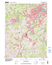
1997 Map of Fairmont West
USGS Topo · Published 2002About this map
The confluence of the West Fork River and the Tygart Valley River creates the Monongahela River here, anchoring the industrial and civic center of Fairmont. This survey shows the city's mid-century expansion into neighborhoods like Beverly Hills and Garden Village, alongside institutional landmarks including the State Teachers College and East Side High Sch. The map documents a landscape heavily influenced by extraction, with numerous Former Mine labels scattered through the hills near Monongah and Eldora, marking the region's coal legacy.
Find a feature on this map
102 named features on this map. Tap any name to fly to it.
Don’t see what you’re looking for? This feature index may not catch every label — zoom into the map to look around manually.
Map Details
Editions of this 1997 Fairmont West Map
This is the sole edition of this map. No revisions or reprints were ever made.
Other maps of this area

1902 · Clarksburg
USGS Topo · 1:62,500

1902 · Fairmont
USGS Topo · 1:62,500

1904 · Blacksville
USGS Topo · 1:62,500

1905 · Mannington
USGS Topo · 1:62,500

1910 · Clarksburg
USGS Topo · 1:62,500

1923 · Blacksville
USGS Topo · 1:62,500

1923 · Fairmont
USGS Topo · 1:62,500

1923 · Mannington
USGS Topo · 1:62,500

1923 · Clarksburg
USGS Topo · 1:62,500

1925 · Blacksville
USGS Topo · 1:62,500