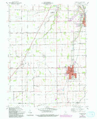
1960 Map of Fairmount
USGS Topo · Published 1994About this map
Fairmount and Jonesboro anchor this 1960 survey of southern Grant County, showcasing a landscape defined by an orderly grid of country roads and the winding path of Back Creek. The area’s spiritual and educational foundations are visible in the numerous rural institutions scattered across the townships, such as Little Ridge Ch, Hill Chapel, and the Liberty Township Sch. Local transport was dominated by the Chesapeake and Ohio railroad line, which bisects the agricultural heartland. A notable concentration of municipal infrastructure appears near the northern edge, where the Marion Municipal Airport sits along the Old Kokomo Road. This document provides a unique record of the transition between small-town residential centers and the surrounding farmland, capturing the exact locations of family landmarks like Oak Ridge Cem and the settlement at Radley.
Find a feature on this map
44 named features on this map. Tap any name to fly to it.
Don’t see what you’re looking for? This feature index may not catch every label — zoom into the map to look around manually.
Map Details
Editions of this 1960 Fairmount Map
Other maps of this area

1953 · Muncie
USGS Topo · 1:250,000

1956 · Muncie
USGS Topo · 1:250,000

1960 · Elwood
USGS Topo · 1:24,000

1960 · Point Isabel
USGS Topo · 1:24,000

1960 · Alexandria
USGS Topo · 1:24,000

1960 · Fairmount
USGS Topo · 1:24,000

1960 · Gas City
USGS Topo · 1:24,000

1960 · Gaston
USGS Topo · 1:24,000

1961 · Marion
USGS Topo · 1:24,000
1962 · Sweetser
USGS Topo · 1:24,000