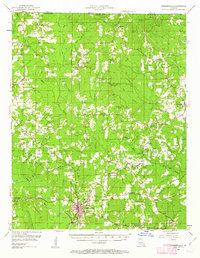
1952 Map of Farmerville
USGS Topo · Published 1963About this map
Farmerville sits at the confluence of the Bayou D'Arbonne and Corney Bayou, serving as the primary hub in a landscape defined by its timber and oil interests during the early 1950s. The northern portion of the region is characterized by industrial activity within the Truxno Oil Field and the preservation of natural space at Donaghey State Park along the state line. For those researching family history, the map provides a dense network of rural landmarks, including the Old Tennessee Cem and dozens of country churches such as Jerusalem Ch and Sweet Lily Ch. This era shows a settled interior before modern developments, where the local economy relied on the creek systems like Little Loutre Bayou and numerous small settlements such as Laran and Marion that functioned as community centers for the surrounding farmsteads.
Find a feature on this map
73 named features on this map. Tap any name to fly to it.
Don’t see what you’re looking for? This feature index may not catch every label — zoom into the map to look around manually.
Map Details
Editions of this 1952 Farmerville Map
4 editions found

Other maps of this area

1927 · El Dorado
USGS Topo · 1:62,500

1930 · El Dorado
USGS Topo · 1:62,500

1933 · Strong
USGS Topo · 1:62,500

1934 · Felsenthal
USGS Topo · 1:62,500

1935 · Drew
USGS Topo · 1:62,500

1935 · Haile
USGS Topo · 1:62,500

1937 · Strong
USGS Topo · 1:62,500

1937 · Felsenthal
USGS Topo · 1:62,500

1938 · Felsenthal
USGS Topo · 1:62,500

1939 · Felsenthal
USGS Topo · 1:62,500