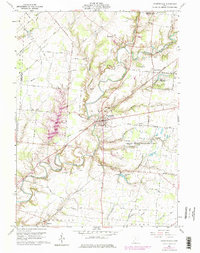
1960 Map of Fayette
USGS Topo · Published 1975About this map
The East Fork Little Miami River carves through the landscape of the Virginia Military District, anchoring a rural community centered on Fayetteville and Saint Martin. This 1960s survey, updated in the mid-1970s, captures a network of small settlements such as Vera Cruz, Chasetown, and Kirbyville linked by an Old Railroad Grade. To the east, the Ursuline School For Girls and the nearby Saint Martin Church serve as significant local landmarks alongside several family-named burial grounds like Kramer Cem and Engle Cem. The expansion of the Indian Creek Wildlife Area and the presence of Diekbrader Lake reflect the shifting land use from strictly agricultural toward conservation and managed recreation. The intricate boundary of the Clermont and Brown County line snakes through the western portion of the map, illustrating the irregular surveying characteristic of this historic district.
Find a feature on this map
73 named features on this map. Tap any name to fly to it.
Don’t see what you’re looking for? This feature index may not catch every label — zoom into the map to look around manually.
Map Details
Editions of this 1960 Fayette Map
4 editions found

Other maps of this area

1911 · Wauseon
USGS Topo · 1:62,500

1913 · Wauseon
USGS Topo · 1:62,500

1913 · Alvordton
USGS Topo · 1:62,500

1943 · Wauseon
USGS Topo · 1:62,500

1944 · Alvordton
USGS Topo · 1:62,500

1953 · Fort Wayne
USGS Topo · 1:250,000

1956 · Fort Wayne
USGS Topo · 1:250,000

1959 · Archbold
USGS Topo · 1:24,000
1960 · Wauseon
USGS Topo · 1:24,000

1960 · Morenci
USGS Topo · 1:24,000