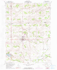
1960 Map of Fayette
USGS Topo · Published 1990About this map
The village of Fayette sits at the heart of this landscape, positioned just south of the Michigan Ohio border where the Michigan Meridian bisects the terrain. This 1960s era survey captures the region's agricultural and hydrologic character, defined by the winding paths of Spring Creek and Bean Creek. To the southwest, the Harrison Lake State Reservation surrounds the waters of Harrison Lake, providing a preserved natural contrast to the grid-patterned fields of Gorham and Franklin townships.
Find a feature on this map
32 named features on this map. Tap any name to fly to it.
Don’t see what you’re looking for? This feature index may not catch every label — zoom into the map to look around manually.
Map Details
Editions of this 1960 Fayette Map
4 editions found

Other maps of this area

1911 · Wauseon
USGS Topo · 1:62,500

1913 · Wauseon
USGS Topo · 1:62,500

1913 · Alvordton
USGS Topo · 1:62,500

1943 · Wauseon
USGS Topo · 1:62,500

1944 · Alvordton
USGS Topo · 1:62,500

1953 · Fort Wayne
USGS Topo · 1:250,000

1956 · Fort Wayne
USGS Topo · 1:250,000

1959 · Archbold
USGS Topo · 1:24,000
1960 · Wauseon
USGS Topo · 1:24,000

1960 · Morenci
USGS Topo · 1:24,000