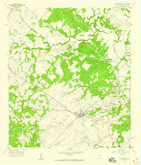
1958 Map of Fayetteville
USGS Topo · Published 1959About this map
Fayetteville serves as the central hub of this 1950s landscape, where the Missouri Kansas Texas railroad cuts a straight line through the rolling creek-fed terrain of the Texas coastal plain. The map documents a deeply rooted rural society defined by small settlements like Roznov, Park, and Rek Hill, each anchored by community institutions and family burial grounds such as Halimecek Cem and Ellers Cem. Significant creek systems, including Clear Creek, Cummins Creek, and Ross Creek, weave between woodlots and pastures, shaping the placement of early homesteads and country churches like Big Spring Hill Ch and Sweet Home Ch. This survey, based on 1956 photography, captures the area before modern expansion, preserving the location of gravel pits, extensive pipeline corridors, and the Historical Marker that notes the region's early importance in Fayette County history.
Find a feature on this map
29 named features on this map. Tap any name to fly to it.
Don’t see what you’re looking for? This feature index may not catch every label — zoom into the map to look around manually.
Map Details
Editions of this 1958 Fayetteville Map
Other maps of this area

1919 · Fayettsville
USGS Topo · 1:62,500

1919 · Giddings
USGS Topo · 1:62,500

1953 · Seguin
USGS Topo · 1:250,000

1954 · Austin
USGS Topo · 1:250,000

1956 · La Grange
USGS Topo · 1:62,500

1957 · Ellinger
USGS Topo · 1:24,000

1957 · La Grange East
USGS Topo · 1:24,000

1957 · Ammannsville
USGS Topo · 1:24,000

1958 · Seguin
USGS Topo · 1:250,000

1958 · Industry
USGS Topo · 1:24,000